Before the coming of the Spaniards, the coastal plains in the northwestern extremity of Luzon, stretching from the Bangui in the north to Namacpacan (now Luna, La Union) in the south, were as a whole known as a progressive region rich in gold.
In 1611, when Pangasinan was created, part of modern La Union was annexed to a new province. By February 2, 1818, growth and prosperity were sufficiently great to compel the Spanish authorities to divide the ancient province of La Union into two: Ilocos Norte and Ilocos Sur. Ilocos Sur then included its present territory, plus the northeastern part of modern La Union and all of Abra (which was then called Abra de Vigan).
In 1846, Abra was made a separate politico-militar province by the Spaniards, but was re-annexed back to Ilocos Sur as a sub-province in 1903 by the Americans. The present province of Abra was finally established in 1917.
The province of Ilocos Sur is located along the western coast of Northern Luzon. It is bounded by Ilocos Norte in the North, Abra in the Northeast, Mountain Province in the east, Benguet in the Southeast, La Union in the South and the Luzon Sea and the Lingayen Gulf in the West.
As of June 30, 2001, the province is composed of:
- 2 cities and
- 32 municipalities and
- 768 barangays.
Approximately 23.7 percent of the province's total land area are crop lands. Aside from La Union, Ilocos Sur is one of the country's major producers of tobacco. Its other major agricultural products include onion, tomato and banana. Industries in the province are mostly small and medium scale ones in the areas of pottery, ceramics and furniture making. These industries absorb more than half of the population total employment.
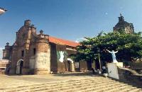
The ubiquitous old and ancestral houses and churches have made the local tourism industry a major contributor to the province's economy. Other tourist attractions include natural scenic spots and industries such as pottery and ceramics.
The province has two distinct seasons: Wet from May to November and Dry during the rest of the year. Monthly average rainfall is estimated at 213 millimeters. Annual average temperature reaches 28.5 degrees centigrade.
Sources: Ilocos Sur Socio Economic Profile, 1990, Provincial Planning and Development Office, Ilocos Sur / Ilocos Sur, 1996, Department of Tourism
Provincial Profile
PROVINCE OF ILOCOS SUR
How to Get There: Ilocos Sur is accessible by land. From Manila, airconditioned bus lines such as Partas, VIron, Philippine, Rabbit and Dominion have daily trips to Vigan City. Other bus lines like Maria De Leon, Farinas, RCJ, and Autobus travel daily to Laoag City passing through Ilocos Sur. Vigan City, the capital, is 408 kilometers north of Manila.
Capital: Vigan City
Climate: The climate is generally dry as defined by the Hernandez type of climate. Classification is characterized by more dry months usually from October to May. However, the southernmost portion (part of Cervantes) is observed to be humid and rain is even distributed throughout the year while the eastern part of Sugpon is dry with rain not sufficiently distributed. August has the most rainfall while January and February have the least. The mean temperature in the province is 27oC. January is the coldest.
Land Area: 2,579.58 square kilometers
Location and Boundaries: Ilocos Sur is located along the western coast of Northern Luzon. It is bounded by Ilocos Norte on the north, Abra on the northeast, Mt. Province on the east,
Benguet on the southeast, La Union on the south and the China Sea on the west.
Political Subdivision: Ilocos Sur has 32 municipalities and 2 cities, namely; Alilem, Banayoyo, Bantay, Burgos, Cabugao, Caoayan, Cervantes, Galimuyod, Gregorio del Pilar, Lidlidda, Magsingal, Nagbukel, Narvacan, Quirino, Salcedo, San Emilio, San Esteban, San Ildefonso, San Juan, San Vicente, Santa, Santiago, Sta. Catalina, Sta. Cruz, Sta. Lucia, Sta. Maria, Sto. Domingo, Sigay, Sinait, Sugpon, Suyo, Tagudin, Candon City and Vigan City.
Languages/Dialects Spoken: Ilocano is the major dialect spoken. Kankanaey and Itneg are spoken in cultural communities. English and Tagalog are the media of instruction in schools.
Population: 594,206 as of Year 2000 Census
Major Industries: Agriculture; Cottage industries include loomweaving, furniture making, jewelry making, ceramics, blacksmithing and food processing.
Brief History:
Before the advent of the Spanish Regime, settlements already existed along the coves or looc in the northern part of Luzon. This region was a progressive trading post familiar to the ancient Japanese, Chinese and Malays.
These settlements called the Ylocos which extended from Bangui in the north to Namacpacan in the south were discovered during the expedition led by Juan de Salcedo in 1572.
Juan de Salcedo decided to establish his headquarters in a settlement along the Mestizo River, then named Kabigaan because of the gabi like plants abundantly growing by the bank of the river. Vigan also became the seat of the Archdiocese of Nueva Segovia and was called Ciudad Fernandina in honor of King Ferdinand. Vigan remains to be the capital city of Ilocos Sur.
On February 2, 1818, the Ylocos was divided into two provinces: Ilocos Sur and Ilocos Norte. At that time, Ilocos Sur encompassed what are now the northern towns of La Union up to Luna and Abra. Also annexed were Lepanto and Amburayan in Mt. Province. Act 2683 passed on March 1917 by the Philippine Legislature defined the present geographical boundaries of Ilocos Sur.