30,000 years ago the Negrito race crossed the Asian continent through the land bridges. With the disappearance of the bridges, islands were formed, Cebu was formed. Being part of the Malay peninsula, Cebu was part of the Malay empire around 500 A.D.
Early inhabitants refer to this island Zebu or Sugbu, whose trade and commerce reaches as far as Thailand and China was well as the near Malay countries.
The people lived in log houses with nipa roofs and used porcelain wares and earthen jars to contain wine and water. They wore gold jewelries and other ornaments to adorn themselves and their clothes. The men wore bahagui at the lower torso and silk turbans on their heads and their bodies were marked with tattoos. The women on the other hand, wore a loose sack-lined blouse, called chambarra, on tops of a square length cloth skirt wrapped around the waist. Some of the women did not wear anything from the waist up, but they painted their lips and nails and decorated their hair with flowers and colorful turbans and wore beautiful jewelries.
The later part of the year 1521 marked the Spanish era with the landing of Fernando de Magallanes and the baptismal to Christianity of Datu Humabon and Queen Juana and their followers. Magallanes was a Portuguese explorer who sailed under the Spanish expedition of 5 ships and more than 200 men. However, he died in the hands of Datu Lapulapu, a chieftain in the island of Mactan. The famous battle marked the Filipinos' aversion to foreign dominance and rule. It was 44 years later after Magellan's death when the expedition of Don Miguel Lopez de Legaspi and Fray Andres de Urdaneta (April 1565) that Christianization and Spanish colonization took place. Legaspi bombarded the palisades of Rajah Tupas and destroyed the village and called it Villa del Santisimo Nombre de Jesus. and became the first Spanish city established by the Spanish Cortes in 1571.
The Philippine revolution although it started in Luzon organized by Andres Bonifacio, had Cebu itself a site of a bloody battle. On April 3, 1898, Cebuano rebels under Gen. Leon Kilat engaged in a three-day fight and had the Spaniards cover behind Fort San Pedro.
Although the revolution did not last, the Spanish-American War, finally ended the Spanish rule when the Americans won in the Battle of Manila Bay. Spain officially turned over the Philippines to the Americans in the Treaty of Paris.
The American set the country to a semi-autonomous rule when the Philippine Commonwealth was establish in 1935, with Manuel Quezon as president and Sergio Osmena, a Cebuano, as vice-president.
Cebu, being the most densely populated island in the country, served as a vital Japanese base during the Japanese occupation in the Second World War which began with the landing of the Japanese Imperial Army on April 1942.
WHY CEBU?
When Cebu was "discovered" by Ferdinand Magellan in 1521, it was truly a discovery, for it opened the eyes of the world to what it did not expect to see.
We had been a bustling trading post in Asia, long before the first of his ships landed, positioned right in the middle of whatwas to become the Philippine Archiepelago.
The island, with its natural port, was a logical destination, and its people, so steeped in the ways of trade and commerce, were its greatest natural resources.
Fast-forward 436 years, and Cebu remains a discovery. It remains that one bright spot, situated right at the geographic center of the archipelago. It is the fastest growing economy in the country, with an average growth rate significantly higher than that of the entire nation, and any other province.
The Province leads 78 other provinces in gross assets, equity and total income.
Frequently been asked: WHY CEBU?
Because there is a reason why we are number one.
There is a reason why this small island leads the entire country in exports of furniture, fashion accessories, carageenan, gifts, toys, and houseware.
There is a reason why Cebu consistently gets the biggest chunk of tourist arrivals yearly, and has become the tourist gateway to Central and Southern Philippines.
There is a reason why Cebu is fast becoming the I.T. and call center capital of the country.
Why Cebu?
Perhaps because the island is naturally situated to become the center of all this action.
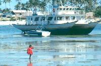
It is a natural port. More than 80% of inter-island shipping capacity is based here, on this small island. It is the most accessible place to and from all points in the country, with more domestic air and sea linkages than even Manila.
It is naturally safe. It does not lie within any earthquake zone or typhoon belt. There are no volcanoes on the island.
It has the necessary, well-balanced infrastructure to remain competitive, and to sustain development. And yet, within minutes from its cosmopolitan quarters, you are immediately transported to resort settings and natural wonders.
Why Cebu?
Most of all, because of its PEOPLE. An independent, self-reliant, entrepreneurial culture pervades the island, which makes its people eminently positioned to seize the opportunities that nature presented it.
We have a highly educated workforce geared towards non-agricultural lines, the reason why Cebu has become the center of global attention for services and information technology.
We are naturally peaceful. We have among the lowest crime rates, and the best peace and order records of all cities and provinces in the Philippines.
Why Cebu? The Island. Its People. We have had four centuries of being discovered by the world. And we invite you to discover today - this island, this people.
FAST FACTS
Population/Language
Cebu Province has a total population of more than 3.8 million. Cebuano is the native tongue. While Filipino is commonly understood and spoken, the English language is widely used in business transactions and educations.
Weather
Cebu is best from December to May when the weather turns dry. it is coolest from December to February, hottest from March to May. Temperature can rise as high as 37°C in the summer. The rainy seasons begins in July bringing torrential downpours that would sometimes inhibit movements.
Philippine Time
Philippine Standard Time is eight hours ahead of Greenwich Meantime.
Dress/What to Bring
Wear natural-fiber, lightweight clothing. You'll fee more comfortable. Bring shorts, hat, sunglasses, bathing suits, insect repellent, flashlight, sun block cream, tough shoes for walking, rubber slippers for the beach.
The Barong Tagalog is the acceptable formal wear for men. Shorts or sleeveless shirts should never be worn when visiting churches, mosques or temples.
Electrical
Most areas in Cebu are supplied with 220 volts, 60 cycles. A plug with 2 flat parallel prongs is the norm.
Money
The Philippine currency is peso, divided into 100 centavos. Next to the peso, the US dollar enjoys wide acceptance. Most foreign currencies can easily be changed at banks, hotels, and authorized dealers. Foreign currency is not readily taken by establishments in Cebu. Major foreign credit cards may be accepted only at mjor hotels, resorts, shops and restaurants. Visitors are advised to bring sufficient amount of change is small bills or coins.
Business Hours
Banks - 9am to 3pm Monday to Friday; Government agencies and offices - 8am to 5pm Monday to Friday; Private firms - 9am to 7pm Monday to Saturday. Most department stores stay open on Sundays and holidays.
Tipping
Bellhops expect a tip, as do waiters, taxi drivers, haidressers, beauticians, and porters. Most hotels and restaurants add 10% service charge on top of the government tax. Tipping 5-15% of the bill appropriate if no service charge is included.
Public Transport
Getting around Cebu, one may take a colorful jeepney or a bus at a minimal fare. Tricycles (motorcycles with sidecars) are popular in outlaying areas and in the suburbs, quiet
GEOGRAPHY
Cebu is an elongated island some 250 kilometers from North to South and 45 kilometers across at its widest point. It is central to the Philippine archipelago and some 600 kilometers south of Manila.
This location combined with a sheltered deep water harbour has made Cebu the base for most of the country's domestic shipping and the gateway to the central and southern Philippines.
The island's area of 5,000 square kilometers supports over 3.8 million people of whom over 2.3 million live in Metro Cebu.
The east and west coasts are separated by a mountainous spine which rise to 1,000 meters. The climate is warm, generally 23 to 33° C. Rainfall is evenly distributed throughout the year, except for the summer months from March to May which are dry.
Beaches, coral atolls, islands and rich fishing grounds surround Cebu.
Cebu's central location, proximity to unusually exotic tourist destinations, ready access to a diversity of plants, animals and geological wonders within the island, and remoteness from earthquake and typhoon activity are some fo the special attributes which help maintain Cebu's track record.
DEMOGRAPHICS
Although Cebu comprises only 1.6% of total land mass and 4% of the population of the Philippines, it produces 9% of total Philippine Exports.
LOCATION
Center of the Visayas islands 569 kilometers South of Manil
AREA
5,000 sq.m.
CAPITAL
Cebu City
POPULATION
Cebu island - 3.8 milion
Metro Cebu - 2.3 million
(50% of the total)
LANGUAGES & DIALECTS
Cebuano (98% of population)
Filipino, English, Fookien
TOPOGRAPHY
Elongated; approximately 250 kilometers long and 45 kilometers at its widest point. Predominantly rugged & mountainous. Its highest peak is 1,000 meters above sea level.
CLIMATE
Generally fair temperature range 23 to 33° C, 73-91° F
TRANSPORTATION
Today, nearly 8 km. of shipping berths line Cebu's deep water port area, now the largest and busiest outside Manila. Efficient container handling, trucking and storage is available. the modern Mactan International Airport is a major international gateway with direct flights to many countries. B747-400 aircraft at maximum takeoff weight can use the airport in all weathers.
AIR TRAFFIC
Cebu's International Airport on Mactan Island facilitates comfortable, easy movement for both international and domestic travelers. The number of weekly international flights to and from Mactan is constantly increasing.
INTERNATIONAL DESTINATIONS
Cebu has regular direct international flights to the following destinations. - Singapore - Hongkong -Taipei - Shanghai - Guangzou - Incheon - Busan( Pusan) - Jeju
- Narita - Kota Kinabalu - Seoul - Doha (Qatar)
Brief History
A flotilla of 5 ships with a crew of 237 sailed out of Seville, Spain on August 10, 1519 with Portuguese Explorer Fernando de Magallanes at the helm. In his earnest quest for the famed Spice Islands (Moluccas), the Spanish navigator traversed the Cape Verde Island of Brazil in the course of his two-year long and arduous voyage.
His patience and determination paid off on March 16, 1521 when land was first sighted by his men. The day after, Magellan learned that he committed an error in latitudinal calculations since he wound up in an obscure island named Homonhon, some 10 degrees too far northwards. Upon further exploration, it turned out that Magellan and his men discovered not only one but several island groups - an archipelago.
March 29, 1521 marked Magellan’s discovery of Limasawa island in Leyte where the first Christian mass was held. The rustic comforts of Limasawa provided the long overdue respite for the weary voyagers with the help of Magellan’s loyal Malay slave, Enrique de Malacca. As Magellan’s interpreter, he was responsible for introducing the sailors to the locals. Food was aplenty and the voyagers were rejuvenated after a week of badly needed rest.
Replenishment of the ships’ supplies proved to be easy as the mariners got their supplies from three big islands: Coulon (Leyte), Pooson (Camotes) and Zubu (Cebu). Magellan and his crew sought the graces and assistance of King Limasawa in the procurement of their supplies.
The Portuguese navigator and his men first set foot in Cebu on April 7, 1521 where their vessel was moored at the port of Cebu. Antonio Pigafetta, Magellan’s chronicler described the sights and nuances of early Cebuano culture: “The houses were built with logs and had ladders made of wood and were roofed with nipa. Many sailing vessels from Siam (Thailand), China and Arabia were docked at the port. The people ate from porcelain wares and used a lot of gold and jewelry for decoration of their bodies and clothing. Their wines were in jars. Men tattooed their naked bodies, covering their private parts with Bahagui and silk turbans were on their heads. About their girls, they were beautiful and almost as white and as large as our girls although naked from waist up. Upper class women wore a sack-like blouse called Chambara on top of a square length cloth shirt tied tightly around the waist. The women painted their lips and nails with bright colors, adorned their bodies with jewelries, but all of them were barefooted.”
A religious milestone occurred in Cebu with the baptism of Zubu’s King Humabon and wife Queen Juana and 400 of their people, signaling the spread of Christianity all over the islands. However, along with the advent of Christian proselytizing, the islanders were subjugated to Spanish sovereignty. The Spanish reign in Cebu proved to be short-lived following the death of Magellan on April 28, 1521 in the rebellious hands of valiant Zubu warrior Lapulapu.
Undaunted by the fate of Magellan, forty years later Spanish colonizer Miguel Lopez de Legaspi and Fray Andres de Urdaneta set forth their sails to conquer Cebu. Legaspi reached Cebu on April 27, 1565 as the second Spanish conquistador. With the defeat of Rajah Tupas, leaving in his midst the village in shambles, Villa del Santisimo Nombre de Jesus rose from the ruins. This was named after the famous miraculous image of Senor Santo Nino de Cebu that was found unscathed among the ashes of a dwelling burned by Spaniards. However, the settlement which Legaspi built as another symbol of Christianity in the island, stood as an omen; portending decades of Spanish colonial regime.
Miguel Lopez de Legaspi then urged his men to construct what is now the oldest and smallest fort in the country: Fort San Pedro. As Spain intensified its colonization efforts, indignant islanders showed opposition by way of intermittent attacks against the colonizers. Thus the rebellion paved the way to the construction of Fort San Pedro, a Spanish military stronghold.
The streets of Tres de Abril and V. Rama were the sites of a fierce battle on April 3, 1898 when General Leon Kilat of Bacong, Negros Oriental spearheaded the revolution against Spanish colonialism. The Spaniards sought refuge at the Fort San Pedro and three days of relentless attacks would have spelled victory for the rebels were it not for the propitious arrival of the Spanish armada.
However, the fort fell to the hands of the native Cebuanos when Americans commanded by Commodore George Dewey vanquished the Spanish fleet in December 1898 in the battle of Manila Bay. With the American reign in full force in 1901, then Senate Pro Tempore and late President Sergio Osmena, Sr. and then Congressman and majority floor leader in the House of Representatives, the late Senator Manuel Briones vigorously lobbied for Philippine Independence.
Cebu metamorphosed in more ways than one, but always for the better. From a sleepy fishing village to a fledgling trading port in 1521, from the first Spanish settlement named Villa del Santisimo Nombre de Jesus in 1575 to a municipality in 1901, Cebu finally became a chartered city on February 24, 1937. Being the first and oldest city in the country, antedating Manila by 7 years, having the oldest school and oldest street and being the cradle of Christianity in the Far East (i.e. Magellan’s cross planted in Cebu as a symbol of natives embracing the Christian faith), Cebu is replete with historical first’s.
February 24, 1937 was a milestone in Cebuano history as Cebu City was granted its charter by virtue of Commonwealth Act No. 58 enacted by Congress on October 20, 1936. The late Senator Vicente Rama, formerly representative of Cebu’s 3rd district was instrumental as author and sponsor of the bill. It was at that time that Secretary of Interior Elpedio Quirino appointed the mayor and board members of Cebu City in his capacity as representative of Manuel Quezon.
Shortly after the landing of the Japanese Imperial Army in Cebu City on April 10, 1942, the entire province became the principal Japanese base due to its strategic location and substantial population. Cebu finally saw the light of freedom in March 1945 when American liberation forces landed in Talisay town. Liberation came in full circle in March 1946 and to restore law and order, a civil government dubbed as Philippine Civil Affairs Unit (PCAU) was established in the city.
In April 1965, the entire Christian world focused its attention on Cebu City, considered as the cradle of Christianity in the Far East as it played host to the 40th Anniversary of Christianity in the Philippines. The celebration highlighted the contributions of Miguel Lopez de Legaspi and Fray Andres de Urdaneta in proselytizing Christianity by way of establishing a Spanish settlement in the province. In a country where Catholics predominate, the conferment of the San Agustin Church to the title Basilica Minore del Santo Niño proved to be a momentous occasion as Rome sent its representative Papal Legate, His Eminence Ildefonso Cardinal Antonuitte.
Located between 9º25’ N & 11º30’ N and between 123º 25’ E & 124º 30’E in the center of the archipelago. Cebu is 365 miles south of Manila and can be reached in an hour through air travel.
Cebu is characterized by narrow coastlines, limestone plateaus, coastal plains but with predominant rolling hills and rugged mountain ranges traversing the northern and southern lengths of the island. Although Cebu’s steep mountains reach over 1,000 meters, the island lacks substantial forest cover. In the towns of Bogo, San Remigio, Medellin and Daan Bantayan at the northern tip of the province, considerable flat tracts of land are found. Of the three biggest islands, Mactan and Bantayan are relatively flat while Camotes is hilly.
Cebu’s weather is relatively moderate, having no distinct wet and dry season, the perfect vacation spot for all seasons. One can bask under the sunshine the whole year through since Cebu is blessed with tropical climate with generally fair temperature range of between 23 - 33 degrees cel.(73-91 degrees far.) Coolest temperature can be felt in January and warmest in May.
Average Annual Rainfall 1,638.20 mm
Minimum Monthly Rainfall 50.40 mm
Maximum Monthly Rainfall 206.50 mm
Mean Temperature Range 26.49 C - 28.79 C
Minimum Temperature 22.69 C
Maximum Temperature 33.19 C
Per data gathered by the Statistics Office as of Aug. 1, 2007, Cebu has a population of about 3,848,919 with the city proper accounting for the 798,809. Being the second largest metropolitan area in the country after Manila, migrant workers from neighboring islands in the Visayas contribute immensely to the working clan population.
Cebuano is the dialect in the province, which is also widely spoken in the Visayas and Mindanao. Tagalog and English are also spoken and understood.
Cebu Province
The nine major cities in Cebu province are Bogo, Carcar, Cebu, Danao, Lapu-lap0u, Mandaue, Naga, Toledo & Talisay while there are 44 towns or municipalities. Facing Bohol Strait is the island’s capital, Cebu City and historic Mactan Island lies just across the city’s harbor.
Cebu City is bounded by the city of Mandaue and the municipality of Consolacion in the north; city harbor and Bohol Strait in the east; Talisay City in the south and Toledo City in the west. Of the 80 barangays comprising the city, 30 are categorized as mountain barangays with land area totaling 27,797 hectares. There are 6 congressional districts, 6 component cities, namely: Bogo, Carcar, Danao, Naga, Toledo and Talisay; 3 highly urbanized cities: Cebu , Lapu-lapu and Mandaue; 44 municipalities; and 1,203 barangays.