Zamboanga Del Sur - The Colors Of Ethnic Zamboanga
BRIEF DESCRIPTION
The province of Zamboanga del Sur is bounded on the north by the province of Zamboanga del Norte; on the south by the Moro Gulf; on the southwest by Zamboanga Sibugay; and on the east and northeast by Lanao del Norte, Misamis Occidental, and Panguil Bay.
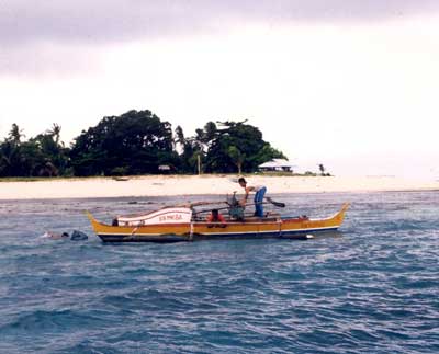
The original inhabitants of the Zamboanga peninsula were the Subanons, who settled along the riverbanks. The next group of settlers to arrive were Muslim migrants from the neighboring provinces. The Maguindanaoans and Kalibugans were farmers; the Tausugs, Samals, and Badjaos were fishermen; and the Maranaos were traders and artisans. The Muslim settlers also looked on mat weaving as its major occupation.
Then came an exodus of migrants from nearby provinces. Historians say that majority of them came from the Visayas, Cebu, Bohol, Negros, and Siquijor. Together with the original settlers, these pioneers helped develop Zamboanga del Sur into the abundant and culturally diverse province that it is.
Today the province comprises two congressional districts with 26 municipalities and one component city. Pagadian City, its capital, with a total of 681 barangays, has been declared as the new regional seat of Region IX.
ZAMBOANGA DEL SUR HISTORY
Like some of the places and cities found in the Philippines (and in Southeast Asia), Zamboanga del Sur was, for the most part, built slowly upon the foundations of various migrants and settlers; it wasnt a settlement built by one tribe which later expanded. The name Zamboanga itself came from the Malayan word Jambangan, meaning a place of flowers. The very first settlers of the area which would ultimately be known as Zamboanga del Sur were known as the Subanons or Subanens, whose name literally means river folks. They settled on the riverbanks and almost all were farmers who practiced the slash and burn method of agriculture. It wasnt long afterwards, though, that they were joined by the Muslim immigrants who came in from neighboring towns, with some coming from as far away as Malaysia. The Muslims were broken down into groups depending from where they came, and their professions were also different: the Maguindanaoans and Kalibugans were mostly farmers by trade; the Tausugs, Badjaos, and Samals were fishermen, and finally, the Maranaos were traders and artisans. A major occupation for the Muslims, however, was mat weaving, which is still very much practiced today. During the following years, more and more people from nearby provinces migrated to the area. Most came from Visayas, namely, Cebu, Negros, and Bohol. Together, these people helped form Zamboanga del Sur into the vibrant province it is known today.
When the Moro Province was established, composing of five districts (Cotabato, Davao, Sulu, Zamboanga, and Lanao), Zamboanga became its capital. When the five districts became individual provinces in 1940, Zamboanga City became the capital of Zamboanga province. After World War II, the capital was transferred to Dipolog and Molave became the provincial capital of Zamboanga when Republic Act 286 was passed on June 16, 1948.
On June 6, 1952, by virtue of Republic Act 711, Zamboanga province, which encompassed the entire peninsula in the southwestern Mindanao, was split into two, with Zamboanga del Sur being one of the half. Zamboanga del Sur became the 52nd province in the Philippines, originally having 11 towns which were later broken down into 42 municipalities and one city, Pagadian. Pagadian City also became Zamboanga del Surs capital.
GEOGRAPHY
Zamboanga del Sur occupies the southern section of the Zamboanga peninsula that forms the western part of the Island of Mindanao. It is located within a longitude of 122º 30"" and latitude of 7º 15"" north. It has a total land area of 473, 491hectares or 4,734.91 sq. m.
Stretching northward from Sibugay in the southwest and running along the northern boundary to Salug Valley in the east is the province mountainous countryside. The coastal plains are extending regularly from south to west then spreading into wide flat lands when reaching the coastal plains of the Baganian peninsula in the southeast.
POLITICAL SUBDIVISION
Zamboanga del Sur consists of two congressional districts with 26 municipalities and one city, with a total of 681 barangays.
LANGUAGE / DIALECT
The major dialect is Cebuano, spoken by 61.31% of the population. Also spoken are Tagalog, Subanon, Chavacano, Ilonggo, Maguindanao, Tausug, Boholano, and Ilocano.
POPULATION
As of the year 2007 census, Zamboanga del Sur had reached a population of 914,278.
CLIMATE
The province has a relatively high mean annual rainfall that varies from 1,599 millimeters in drier areas to 3,500 millimeters in the wettest portion. Temperature is relatively warm and constant throughout the year ranging from the minimum temperature of 22 to 35 degrees Celsius.
TRADE AND INDUSTRY
Agri-based manufacture of coco oil, livestock feed milling, rice/ corn milling, including the processing of fruits; gifts and housewares made from indigenous materials like handmade paper, roots, rattan, buri, and bamboo; wood-based manufacture of furniture and furniture components from wood, rattan, and bamboo; marine and aquaculture including support services; construction services and manufacture of marble, concrete, and wooden construction materials.
OVERVIEW
The early history of Zamboanga del Sur is similar to that of Zamboanga del Norte, inevitably linked with that of Zamboanga City, the center of Mindanao then, specially during the American Era.
When Zamboanga City became a chartered city on October 12, 1936, it included the Zamboanga Peninsula and the island of Basilan, making it the largest city in the world in terms of land area.
This changed in 1948 when Basilan became a separate province and when Republic Act No.711 on June 6,1952 created two more provinces out of the Zamboanga City area.
One of these provinces was the Province of Zamboanga del Sur.
The status quo prevailed un til February 2001 when Zamboanga Sibugayand 16 of del Sur's southern towns came into its own.
GEOGRAPHY/POLITICAL SUBDIVISION
Zamboanga del Sur is in northwestern Mindanao. It is bounded on the north by Zamboanga del Norte, to the west by Zamboanga Sibugay, on the east by Misamis Occidental, Panguil Bay, and Lanao del Norte, and on the south by the Moro Gulf and the Basilan Strait.
Zamboanga del Sur has an aggregate land area of 4,694.78 square kilometers with an irregular coastline.
The landscape consists of a flat coastal plain giving way to mountains in the interior. The biggest bays are Dumanquilas, Maligay, and Pagadian Bay. A small peninsula extends into the Moro Gulf.
Four rivers cross the plain to deltas where major towns are located. These are the Kumalarang, Sibuguey, Dinas, and Labangan Rivers. Zamboanga del Sur now has 27 towns.
ETHNIC DISTINCTION
Pagadian City is a melting pot that includes the Tiruray, Manobo, Maranao, and Maguindanao ethnic groups. The dominant ethnic group in Zamboanga del Sur is the Subanen whose enclaves are in tne towns of Kmnaiarang, and Lapuyan.
MAJOR INDUSTRIES
Zamboanga del Sur's Land is highly fertile, where rice, corn, coconut and rubber are consistently produced. Rich and teeming waters mark fishing as a major industry. Its dense forests also contribute to a thriving wood industry. With valuable mineral deposits, manganese, copper, and nickel and mined in Kumalarang.